 TRAIL NAME: Mount Wilson (from Chantry Flats via Sturtevant/Gabrielino Trail) – Angeles National Forest (Part of the SoCal Six Pack of Peaks)
HIKE DATE: Friday, August 5, 2016
HIKE PREREQUISITE: Must have completed a LATH Level 6, 7 or higher hike.
MEETING TIME: 6:00am – 6:15am
(Please be on time. We’ll wait 15 mins past the meeting location. We leave the meeting point at 6:15am)
Return Approx: 2:30pm
HIKE LEAD: Tony Ramos
HIKE LEVEL: Level 8 – (Strenuous, uphill switchbacks. Distance with steady elevation gain. No Beginners, No Kids, No Dogs)
 WHAT IS A HIKING LEVEL?:
Find out more about hiking levels here:
http://latrailhikers.com/about/hike-levels/
HIKE RSVP:
https://www.facebook.com/latrailhikers/events
HIKE DURATION: 7.5 to 8.5 hours (Approx.)
HIKE DISTANCE: 14.5 Miles (Approx.)
 ELEVATION GAIN: 4,200 ft. with top Elevation of 5,713’ (1741 m)
MEETING LOCATION:
Arco AMPM Gas Station
5 W. Foothill Blvd
Arcadia, CA 91006
(Click on the address or Scroll down for Meeting Point map)
PARKING: $5 Day or $30 annual Adventure Pass to park at Chantry Flats. Please get this ahead of time from a local Sports store like REI stores, Big 5 Sporting Goods, and other retailers prior to the hike. Please try to get this prior to the hike. We suggest carpooling together.
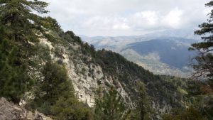
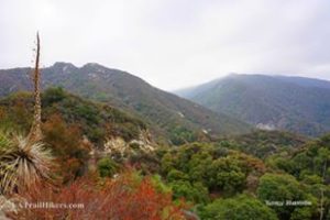
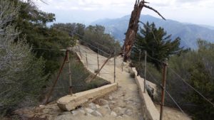
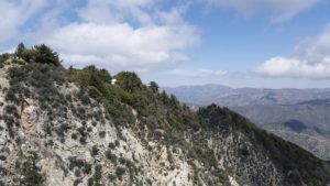
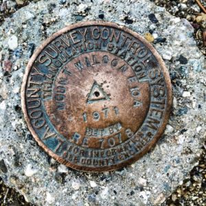
HIKE WALKTHROUGH: Mt. Wilson is one of the better-known peaks of the San Gabriel Mountains, located with the San Gabriel Mountains National Monument and Angeles National Forest in Los Angeles, County.1 The summit is also known for the many radio and television antennae that reside on the peak as well as the famous Mount Wilson Observatory. We will start at the Chantry Flats trailhead above Arcadia and may take a quick detour to visit the now probably dry Sturtevant Falls. We will then head back to the Gabrielino Trail junction, head towards Spruce Grove Campground and then take Sturtevant Trail up with a bit of a steep incline and multiple switchbacks which eventually get us up to the summit. We will walk across some paved roads to the side of the antennas and water fountain and take our lunch break.
Heading back down, we will take the other trailhead which connects to a dirt road known as the old “Toll Road” and follow it until reaching the Winter Creek sign and trail. This is a mostly downhill walk eventually reaching Hogee’s Camp. We will continue on the Upper Winter Creek Trail as opposed to Lower Winter Creek which has some better views of the great scenery as you descend towards the parking.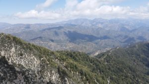
This is the first of six southern California summits in what is called the So Cal 6-Pack of Peaks Challenge series. This is a good training for anyone preparing for more advanced hikes such as Mt. Whitney, Half Dome or the JMT. Each of the 6-Pack is progressively higher in altitude, and all have respectable distance and vertical elevation gain.
1 https://en.wikipedia.org/wiki/Mount_Wilson_(California)
WATER/ELECTROLYTES REQUIRED. WATER/ELECTROLYTE CHECK WILL BE PERFORMED. If you do not take enough water/electrolytes or are not appropriately equipped for this hike, you will be turned away from doing this hike with us even if you show up. Please note, that we have expectations for Level 8 hikers. Read all the details in the link above.
REQUIRED: WATER, at least 2 to 3 Liters of water and a small water 16/20 bottle. The small bottle should contain electrolytes (sports drink, vitamin water, or something equivalent to it – Electrolyte tablets work best because they can easily be added to your water), comfortable hiking shoes/boots with grip, a hat, sunscreen, a few good quick snacks, and a small packed lunch.
 EXPECTED: You will be in a group environment, so , as a Level 8 hiker, you will be expected to:
– Come prepared with all the necessary hiking gear for this trail (water, electrolyte supplements, nutrition, gear, attire and footwear)
– Keep up together with the hiking group at all times.
– Keep a steady pace going uphill. Unlike lower level hikes, this hike is timely and intended to be completed in an adequate time.
RECOMMENDED: Trekking Poles or a hiking stick will help, Light-weight hiking pants, Bug / Mosquito spray, Sunglasses, Beanie, Scarf, Gloves, Jacket, Layers of clothing for the upper body, Hiking Socks, Food (many citrus or nut-based snacks, a sandwich).Rain gear (light water proof jacket with hood), flash light,
IS IT DOG-FRIENDLY?: No. Although dogs are allowed in the area, we are requesting NO pets for this strenuous level hike.
HOW DO I PARTICIPATE WITH THE GROUP ON THIS HIKE?
1. Read the Hike’s Details we link at the very top of this page.
2. Make sure that the Hike Level accommodates your hiking experience.
3. If, and only if it suits you, then RSVP for this event and show up the day of the hike with all necessary gear and water (we mention everything you need on the details page for this hike).
 MY FRIEND SAID I CAN DO THIS HIKE, I SHOULD BE ABLE TO DO IT, RIGHT?
We take your safety quite seriously, and would not like for you to attend a hike you’re not ready for. You know your body and hiking experience better than your friends. Whether you are a first-timer or an experienced hiker, please read our hike details page as the hike may not suite your experience level. We have a better experience if every hike has hikers of the intended level.
DISCLAIMER: LA Trail Hikers and its Leads/Organizers/Participa
MAP: