 TRAIL NAME: Inspiration Point via Castle Canyon (for this specific hike date)
HIKE DATE: Wednesday, April 04, 2018
MEETING TIME: 8:00 am – 8:20 am
(We’ll wait 20 mins at the meeting point. We leave the meeting point at 7:20 am, please be prompt)
Return approx: 4:30 pm
HIKE LEAD: Gaspar Marroquin
HIKE LEVEL: Level 7 – (Workout, higher moderate hike. Long distance, switchbacks, and a mostly steady 30/mile pace. No Beginners, No Kids, No Dogs)
WHAT IS A HIKING LEVEL?:
Find out more about hiking levels here:
http://latrailhikers.com/about/hike-levels/
HIKE RSVP:
https://www.facebook.com/latrailhikers/events
HIKE DURATION: 5.5 Hours (Approx.) 6 Hours (Approx.)
HIKE DISTANCE: 9.5 (Round Trip) 11.5 Miles approx. (Round Trip) Longer Way
HIKE MEETING LOCATION:
Ralph’s Grocery Parking Lot (South of 210 fwy)
Meet inside the parking lot area closer to the corner of Walnut and Lake Ave.
160 N Lake Ave
Pasadena, CA 91104
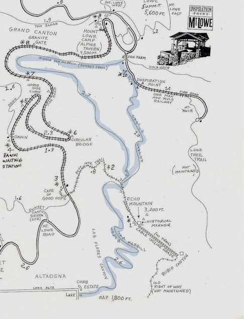
HIKE WALKTHROUGH via Castle Canyon: This version is shorter in distance, but steeper after Echo Mountain. Requires good energy/stamina the the other version of this hike. We begin at the corner of Lake Ave and Loma Alta Dr. and enter the through the Cobb Estate gate. We will head to and go up to the top up the Lower Sam Merril trail which contains switchbacks along side the mountain. Quite demanding, but a great workout. It is about 2.6 miles to the first stop with mile markers to the top of Echo Mountain. We will spend short break time at the top of Echo Mountain’s entrance while we get some water and give everyone instructions on the next section of the hike. Then we continue on for about 2 more miles uphill on some good inclined switchbacks along on the Castle Canyon trail until we get to Inspiration Point’s viewing area. The switchbacks here are usually a good workout for most people. So, we’ll work our way up with a limited number of breaks. Once there, we’ll take a extended break for snacks and extended views of the areas being pointed to from the named lookout pipes (weather permitting). To return, we will head back down the Middle Sam Merril trail, or what we like to call, the Sunset Trail. Keep in mind that there is plenty of down hill and that does cause for much impact on your ankles and knees. We’ll make sure to take a few stops along the way to easy up the pounding as going down may be more of a workout or exhaust factor than going up on your legs and feet, but we’ll try our best to make sure our trip down is at a decent pace. We’ll exit through the Cobb Estate gate to finish the hike. On the drawn map, it’s the blue line trail.
HIKE WALKTHROUGH via Mt Lowe Railway: This version is longer, but with manageable uphill along the fireroad. This version is great for first time visitors. We begin at the corner of Lake Ave and Loma Alta Dr. and enter the through the Cobb Estate gate. We will head to and go up to the top up the Lower Sam Merril trail which contains switchbacks (zig-zag) along side the mountain. Quite demanding, but a great workout. It is about 2.6 miles to the first stop with mile markers to the top of Echo Mountain. We will spend short break time at the top of Echo Mountain’s entrance while we get some water and give everyone instructions on the next section of the hike. This time around we’ll take the Echo Mountain Trail (0.8 miles) until we reach the main Fire Road which will take us the rest of the way around the mountain (the longer, but easier way). Just before getting to Inspiration Point, we’ll stop at Mount Lowe Camp (Alpine Tavern), where we’ll find some outhouses to use. We’ll take a small break there and continue on until we get to our destination. Once there, we’ll take a extended break for snacks and extended views of the areas being pointed to from the named lookout pipes (weather permitting). To return, we will head back down the Middle Sam Merril trail, or what we like to call, the Sunset Trail. Keep in mind that there is plenty of down hill and that does cause for much impact on your ankles and knees. We’ll make sure to take a few stops along the way to easy up the pounding as going down may be more of a workout or exhaust factor than going up on your legs and feet, but we’ll try our best to make sure our trip down is at a decent pace. We’ll exit through the Cobb Estate gate to finish the hike. On the drawn map, follow the trail sections that have an asterisk in front of the number, for example: *1, *2, *3…
WATER REQUIRED. WATER CHECK WILL BE PERFORMED. If you do not take enough water or are not appropriately equipped for this hike, you will be turned away from doing this hike with us even if you show up. Please note, that we have expectations for Level 7 evening hikers. Read all the details in the link above.
REQUIRED: WATER. At least 3 to 4 Liters of water, electrolyte supplement drink/tablets, a hat, comfortable hiking shoes and a few good snacks.
RECOMMENDED: Additional water or pocket snacks for the way. Try to pack lightly as you’ll be using plenty of your energy getting to the top and coming back down the trail. Sunscreen, we’ll be out in the sun and you’ll want to be protected against uva and uvb rays. Hiking poles help you going up hill and don’t get you as tired when you’re going downhill. During hot days, freeze at least 2 small water bottles to keep handy on when it gets really hot. Arrive early to the meeting point if you need to get some supplies or water from the Ralph’s.
RESTROOMS: There are no restrooms along the way, or at the trail head. So please make sure you go before the hike, or use the one at the meeting point. (There will be one stop at the campground area near the top where there are stalls, but no running water).
IS IT DOG-FRIENDLY?: Yes, but experienced hiking dogs only (Dogs on must be on a Leash). Must bring all hiking gear needed for your pet.
HOW DO I PARTICIPATE WITH THE GROUP ON THIS HIKE?
1. Read the Hike’s Details we link at the very top of this page.
2. Make sure that the Hike Level accommodates your hiking experience.
3. If, and only if it suits you, then RSVP for this event and show up the day of the hike with all necessary gear and water (we mention everything you need on the details page for this hike).
MY FRIEND SAID I CAN DO THIS HIKE, I SHOULD BE ABLE TO DO IT, RIGHT?
We take your safety quite seriously, and would not like for you to attend a hike you’re not ready for. You know your body and hiking experience better than your friends. Whether you are a first-timer or an experienced hiker, please read our hike details page as the hike may not suite your experience level. We have a better experience if every hike has hikers of the intended level.
DISCLAIMER: LA Trail Hikers and its Leads/Organizers/Participa
MAP: